
The Sedimentation Management Plan
Sedimentation is a natural process where soil, organic matter, and other particles are deposited in bodies of water over time, resulting in reduced depth, water quality and habitat degradation.
The lake was dredged in 1998, and again in 2020 (see below). After the latter a plan was created that aims to address the issue of sediment accumulation within the lake.
The plan outlines strategies and actions to mitigate sedimentation and restore the lake’s health, including:
- Sediment assessment.
- Sediment source identification.
- Best Management Practices (BMPs) to reduce sedimentation.
- Shoreline stabilization.
- Education and outreach.
- Monitoring and using adaptive management.
- Collaboration and partnerships.
Surveys
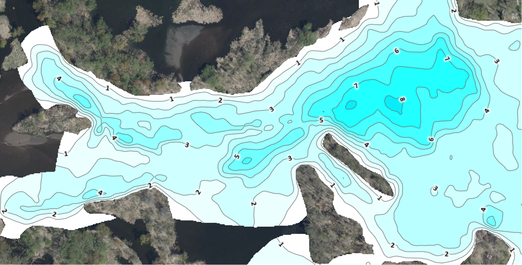
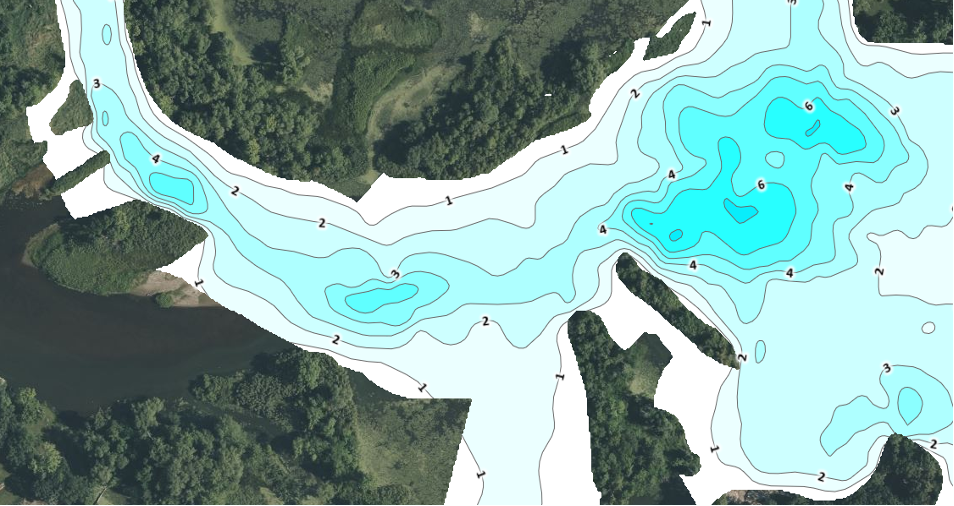
The OLID creates surveys generated using a system called BioBase, which uses sonar to create detailed depth (bathymetry), vegetation and hardness maps of the lake bottom.
Here’s a brief overview of each component:
Click on a map to see a larger image
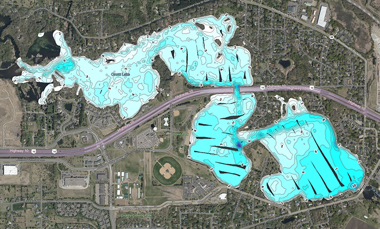
Bathymetry: Refers to the measurement of water depth in a body of water. This map shows the contours and variations in water depth, providing important information about the lake’s topography.
Vegetation: These infrared surveys help identify the distribution and extent of different types of aquatic plants and algae present which is crucial for assessing the ecological health of the lake and determining any potential impacts on water quality, navigation, or recreational activities.
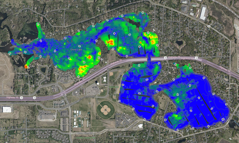
Red = Surface aquatic growth
Green and yellow = Growth at midpoint of the water column
Blue = None or very little vegetation
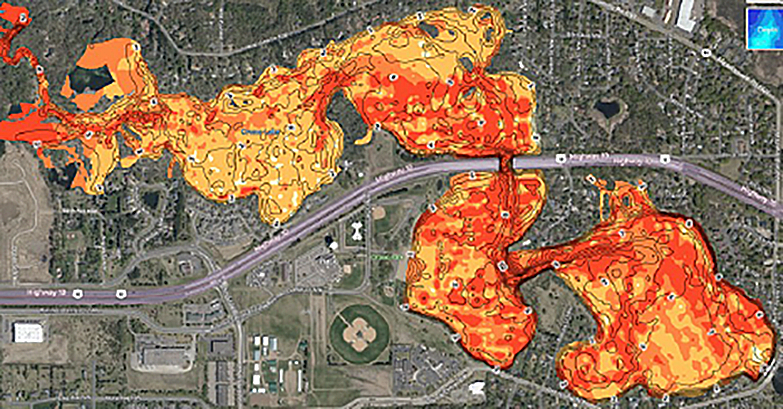
Bottom Hardness: Measures the substrate composition, including sediment types and bottom consistency to gain insight into the sedimentation processes occurring in the lake. This information aids in understanding sediment dynamics, deposition areas, and potential erosion concerns.
By integrating the data from these surveys, the OLID can develop a comprehensive sedimentation management plan. This may include strategies for mitigating sedimentation issues, such as implementing erosion control measures, managing vegetation and conducting periodic dredging activities.
History
Lake Orono was previously dredged in 1998. For more detailed information, please see the following links:
1998 Conditional Use Permit request March 24, 1998 (includes Wenck Sedimentation Study and Environmental Assessment Worksheet)
1998 Lake Orono Dredging Locations
Final results December 21, 1998
In 2011, a mini study was done that indicated the lake was filling up at basically the same rate the 1997 study had calculated, of about 26.3 years.
2020 Dredging
From about 2014 on, residents noticed that the lake was again filling in. Several maps were drawn up that not only included sedimentation but also nuisance native aquatic plants and aquatic invasive species. LOIA met with the City Council in June of 2016 at a worksession to present their concerns.
In 2018, a Lake Orono Refresh study was performed by WSB Associates. With data collected from volunteers, Endangered Resources Inc. and WSB, it was determined that 125,000 cubic yards of material had accumulated, which was a slightly higher rate than previously calculated and 20 years after the previous dredge.
In 2019, an Environmental Assessment Worksheet (EAW) was ordered, which lays out the basic facts of a project such as permitting, informs the public and provides guidance as to how the environment may be protected.
In 2020, a Technical Advisory Panel was hosted by WSB which included representatives from the City, DNR, SWCD, Army Corps of Engineers and OLID to provide comments on the specifics of the project. A Feasibility Study was also done by WSB.
The City ordered the dredge and named the project Lake Orono Restoration and Enhancement (LORE), which also included fish habitat and shoreline restoration.
To fund LORE, several sources of revenue were utilized, including:
- A local option sales tax (LOST) for the City of Elk River’s Active Elk River projects ($1,000,000)
- Funding from a State of Minnesota bonding bill ($1,500,000)
- Lake property owner assessments ($650,000)
- City of Elk River funds ($100,000)
The project was started in September of 2020 and finished in April of 2021 with 140,469 cubic yards dredged at a final cost of $2,693,184.40; significantly under budget.
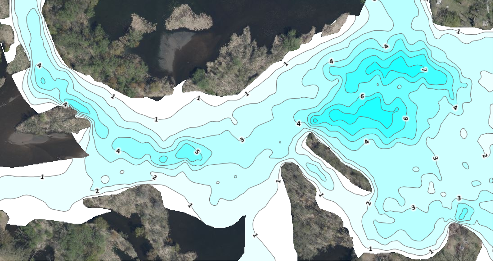
2025 Sedimentation assessment and monitoring report
Surveys of the lake were conducted in 2022, 2023 2024 and in 2025 by the sedimentation assessment and monitoring committee. The surveys conducted in 2022 provided valuable baseline data on sedimentation in the catch basin.
Catch basin monitoring
Key findings from the 2022 to 2025 surveys include:
- The surveys indicate a year-over-year accumulation of sedimentation in the catch basin of 1,481 cubic yards of material.
- Total combined accumulation of sedimentation in the catch basin of 12,879 cubic yards of material.
- Based on sediment accumulation and the need to maintain a 4-foot navigational depth, we project dredging of the catch basin will be required around 2030.
Click on a map to see a larger image
2022
| Water Volume (acre ft) | 35.004 |
| Water Depth Avg (ft) | 4.16 |
| Water Depth Max (ft) | 8.33 |
| Water Depth Min (ft) | 0.19 |
2023
| Water Volume (acre ft) | 30.204 |
| Water Depth Avg (ft) | 3.59 |
| Water Depth Max (ft) | 7.61 |
| Water Depth Min (ft) | 0.14 |
2024
| Water Volume (acre ft) | 27.975 |
| Water Depth Avg (ft) | 3.38 |
| Water Depth Max (ft) | 7.11 |
| Water Depth Min (ft) | 0.22 |
2025

| Water Volume (acre ft) | 27.057 |
| Water Depth Avg (ft) | 3.27 |
| Water Depth Max (ft) | 7.47 |
| Water Depth Min (ft) | 0.10 |
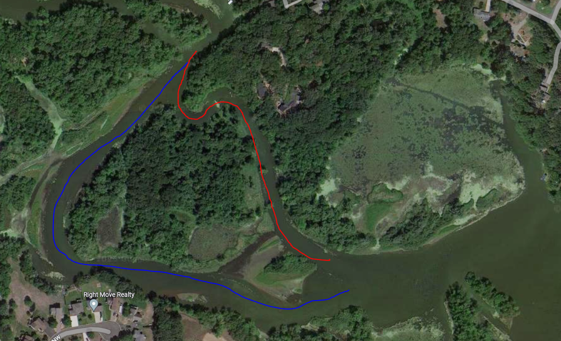
2023 aerial view near catch basin
Potential Sources: Sediment could be from nearby scouring and/or shoreline erosion identified in red below and from upstream locations within the watershed.
Cemetery shoreline stabilization
Orono Lake Improvement District expresses our full support for the Cemetery Shoreline Stabilization Project. This initiative represents a critical investment in the protection and preservation of Orono Lake’s shoreline.
The proposed stabilization efforts will mitigate ongoing erosion, protect adjacent cemetery lands of historical and cultural significance, and provide essential benefits to aquatic and shoreline habitats.
The Orono Lake Improvement District views this project as aligned with our mission to protect, improve, and maintain the lake as a vital natural resource. We support the advancement of this project and stand ready to collaborate with project partners to ensure its success.
